Calgary, Canada June 3, 2021 – Crestview Exploration Inc. (CSE: CRS, Frankfurt: CE7) (“Crestview” or “the Company”) is pleased to announce the completion of 1,684 feet of the 4,500 feet budgeted for the phase 1 drill program at the Cimarron gold prospect (“Cimarron” or the “Property”; see Map 1 below). Three core drill holes have been completed, and we are now moving to the fourth. In addition to the drilling, the company has started evaluating the extension claims at Cimarron. While still early in the process, encouraging sinter float has been observed and sampled on the extension claims both north and south of the core claims.
For additional details on the Cimarron property, the reader is referred to previous news releases.
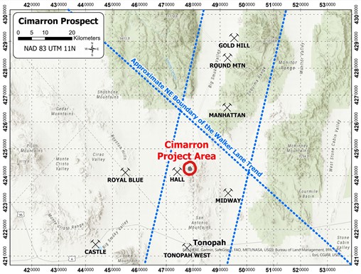
MAP 1: Cimarron Project Area
The Cimarron phase 1 drilling was designed to validate the historic drilling while simultaneously testing the expansion potential at depth. The phase 1 drill program allotted a 4,500’ total footage budget spread between five to nine drill holes drilled between 400’ and 1,000’ depending on alteration and mineralization.
As a reminder to the reader, the Cimarron property was acquired with a large dataset of gold assays for approximately 190 drill holes that date back to the 1980’s. The historic drilling was quite shallow, with the average depth of drill holes less than 200’. The historic dataset includes many intervals of greater than 0.1 opt Au, and a number of the holes were terminated in economic grade. This data set was used to estimate an approximately 50,000-ounce gold resource which was never reported in a 43-101 as the data predates the practice (reference is to an internal mining report by Peter Hahn to Budge Mining Ltd. dated February 17, 1987).
The gold mineralization at Cimarron is hosted in a stacked volcanic rock sequence (rhyodacite, pyroxene andesite, latite porphyry, and vitric tuff) with interbedded mud-flow breccia, which is the primary host rock for mineralization at Cimarron. This unit features poorly-sorted, cobble- to pebble-sized, intermingled volcanic and sedimentary fragments in a fine-grained mud matrix. The alteration observed in the first three holes includes silicification and argillic and propylitic alteration with strong iron oxides.
The three completed core holes are twins of historic reverse circulation holes in each of the three historic resource areas (see Map 2 below).
MAP 2
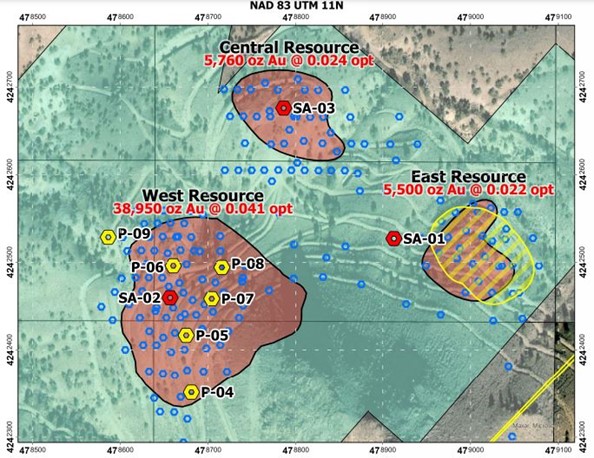
SA-01 is a twin of the historic EB-86, drilled by Echo Bay in 1987. EB-86 was drilled to a depth of 150’, with assays reporting gold mineralization starting near surface and extending to 135’ and grades as high as 0.264 opt Au reported. SA-01 was terminated at a depth of 487’, more than 300’ deeper than EB-86. The hole was collared in latite porphyry, with the mud-flow breccia unit encountered at 23.5’ and extending 34’. The remainder of the hole was drilled in pyroxene andesite, with increased alteration along faults and fractures. Away from structures, only propylitic alteration was observed in the pyroxene andesite.
SA-02 is a twin of the historic C-93, which was drilled by Budge in 1986. C-93 was drilled to a depth of 380’, with gold mineralization starting near the surface and gold grades as high as 0.186 opt reported. The hole was terminated in approximately 60’ of economic grade. SA-02 was terminated in the pyroxene andesite unit at a depth of 627’, more than 240’ deeper than C-93. The hole was collared in the mud-flow breccia host rock, which extended to approximately 568’. The argillic alteration and iron oxides continued in the pyroxene andesite to approximately 570’, giving way to propylitic alteration.
SA-03 is a twin of the historic C-18, which was drilled by Newmont in 1980. C-18 was drilled to a depth of 230’, with gold mineralization starting at the surface and gold grades as high as 0.042 opt reported. The last five-foot sample of the hole was in economic gold grade. SA-03 was terminated at a depth of 570’ which is more than 300’ deeper than C-18. The hole was collared in the mud-flow breccia host rock, which extended to approximately 492’ then transitioned to vitric tuff.
V.P. of Exploration Justin Lowe commented, “The program is going well overall. We had some unanticipated delays early in the program (primarily drill repair and maintenance issues), but those issues seem to have been resolved. Geologically speaking, we are very happy with what we are seeing. The alteration indicators are there, and we have been able to drill these first three twins significantly deeper than the originals. The total thickness of the mud-flow breccia unit was unknown at the start of the program, and we have been encouraged to see it extends much deeper than the original occupants drilled. We have the drilling contractor until June 10th, so I anticipate we will complete one or two more holes depending on the depth. The assay results should be in by late summer, at which point we will plan our next move.”
This News Release was prepared by J.A. Lowe, M.Sc. Geology. Brian T. Brewer, M.Sc., CPG #11508, is a Qualified Person as defined by NI 43-101 and has reviewed and approved the scientific and technical disclosure in this news release.
About Crestview Exploration Inc:
Crestview Exploration is a technology driven, well-funded and experienced exploration company focused on finding gold and silver deposits in mining friendly jurisdictions. The Crestview’s projects Rock Creek, Divide, and Castile Mountain are situated in the Tuscarora Mountains of northern Elko County, Nevada. The company’s Tuscarora properties combined comprise a total of 101 unpatented lode mining claims, with 74 claims at Rock Creek, 19 claims at Divide, and 8 claims at Castile Mountain.
The Cimarron project is located in the San Antonio Mountains of Nye County, Nevada, and is comprised of 53 unpatented lode mining claims, including control of 6 historically producing claims associated with the historic San Antonio mine.
Glen Watson, Chief Executive Officer
Tel: 1-604-803-5229
Email: Glen@crestviewexploration.com
Forward-Looking Information
This news release includes certain information that may be deemed “forward-looking information” under applicable securities laws. All statements in this release, other than statements of historical facts, that address acquisition of the Property and future work thereon, mineral resource and reserve potential, exploration activities and events or developments that the Company expects is forward-looking information. Although the Company believes the expectations expressed in such statements are based on reasonable assumptions, such statements are not guarantees of future performance and actual results or developments may differ materially from those in the statements. There are certain factors that could cause actual results to differ materially from those in the forward-looking information. These include the results of the Company’s due diligence investigations, market prices, exploration successes, continued availability of capital financing, and general economic, market or business conditions, and those additionally described in the Company’s filings with the Canadian securities authorities.
Investors are cautioned that any such statements are not guarantees of future performance and actual results or developments may differ materially from those projected in the forward-looking information. For more information on the Company, investors are encouraged to review the Company’s public filings at www.sedar.com. The Company disclaims any intention or obligation to update or revise any forward- looking information, whether as a result of new information, future events or otherwise, other than as required by law.
NEITHER THE CANADIAN SECURITIES EXCHANGE NOR ITS REGULATION SERVICES PROVIDER HAS REVIEWED OR ACCEPT RESPONSIBILITY FOR THE ADEQUACY OR ACCURACY OF THIS RELEASE
Stay In Touch